OnCoord now exposes the fabric of places — not just coordinates, but the concentration of businesses, services, and amenities that surround them. With the POI Density API, developers can query how many points of interest exist within 1 km and 2 km of any location, broken down by category, along with a single urbanity index that summarises commercial intensity in one number.
Know What Surrounds a Location
A coordinate tells you where something is. POI density tells you what kind of place it is. The difference between a quiet residential street and a commercial high street may be invisible in raw coordinate data, but it becomes immediately legible when you know there are 2,147 points of interest within one kilometre — 606 retail, 325 food, 194 nightlife. That level of context shapes decisions in retail site selection, logistics coverage planning, telecom demand forecasting, and real estate analysis.
Rich Context, One Call
Each response covers two concentric rings — 1 km and 2 km — and breaks counts down across fourteen broad categories as well as three specialized emergency and civic services that are always reported, even when absent:
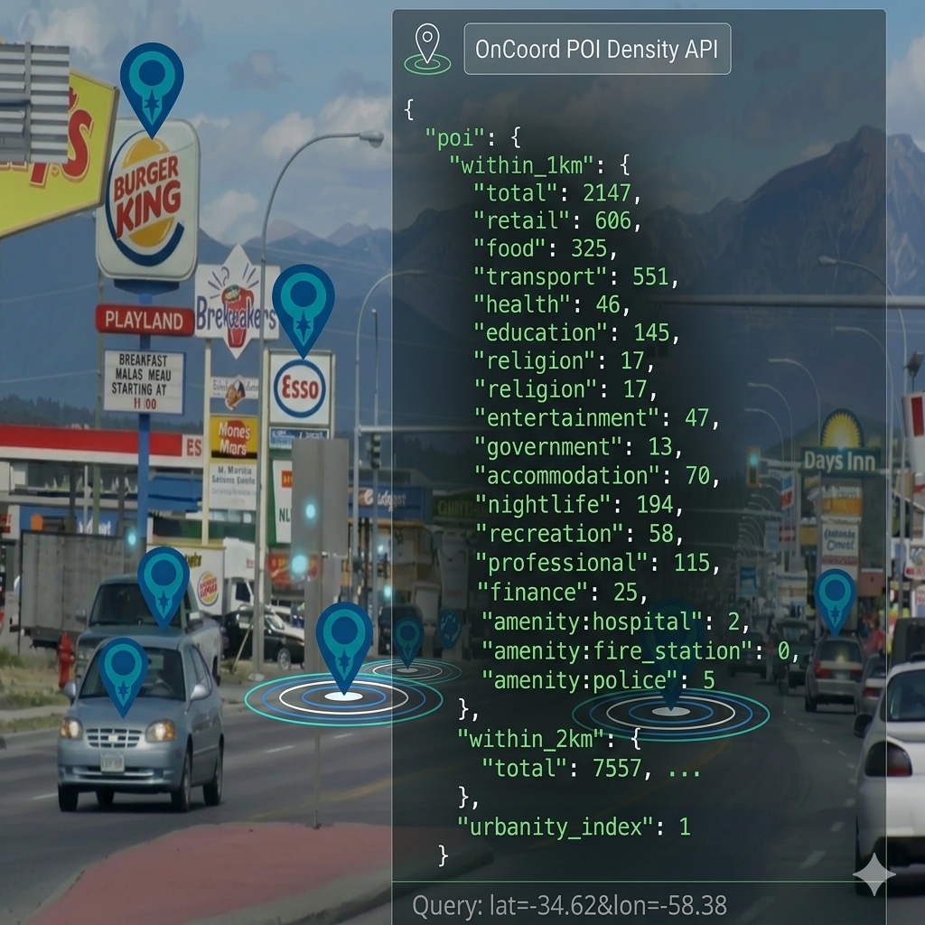
{
  "poi": {
    "within_1km": {
      "total": 2147,
      "retail": 606,
      "food": 325,
      "transport": 551,
      "health": 46,
      "education": 145,
      "religion": 17,
      "entertainment": 47,
      "government": 13,
      "accommodation": 70,
      "nightlife": 194,
      "recreation": 58,
      "professional": 115,
      "finance": 25,
      "amenity:hospital": 2,
      "amenity:fire_station": 0,
      "amenity:police": 5
    },
    "within_2km": {
      "total": 7557,
      ...
    },
    "urbanity_index": 1
  }
}
within_1km / within_2km — counts of all venues within
the respective radius, broken down by category. The 1 km ring is
suited to hyperlocal analysis; the 2 km ring provides a broader
neighbourhood picture.
Broad categories — retail, food, transport, health,
education, religion, entertainment, government, accommodation, nightlife,
recreation, professional, and finance.
Specialized categories — amenity:hospital,
amenity:fire_station, and amenity:police are
always returned, with a count of zero when none are present.
urbanity_index — a 0–1 score derived from the 1 km
counts. High-signal categories such as restaurants, cafés, banks,
pharmacies, supermarkets, and fast-food outlets carry extra weight.
The score compresses non-linearly so meaningful differences in
mid-density areas are preserved without saturating at the top end.
A score of 1 indicates a dense urban core; scores below 0.1 typically
indicate rural or peri-urban locations.
POI Density is available across OnCoord's full coverage area: Mexico, Central America, and South America. See our Countries page for a full list of supported countries.
POI density joins population, terrain, activity, and geocoding to complete OnCoord's picture of any location. Together they answer the questions that matter in practice: where is it, what's the land like, how many people are nearby, how economically active is it — and now, what activity surrounds it.